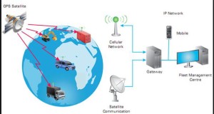
Many motorists should be concerned about the second generation of the Electronic Road Pricing System ( ERP), using the satellite technology. Instead of having gantries, the ERP system will be LIVE on satellite. The $556 million system has island wide coverage and the ability to charge according to the distance travelled. Many of the motorists are bound to have doubts about this system and whether our government is using this as an opportunity to make more revenue.
Actually if our government relies soley on high duty to manage car usage, the charges will actually be higher. The main purpose of having the ERP on satellite is to ensure a fairer calibrated congestion management charging system. The ultimate aim is actually to ease the congestions for roads that are always jammed up during the peak hours.
Roads are priced in such a way that the capacity utilization is optimal or else the infrastructure will be considered under used. There are many other methods to increase the government’s revenue by raising the petrol duty or the car taxes. The system has also other uses such as allowing cupon less kerb side parking. It will also be possible to charge for off peak car usage.
Over that period, the accuracy of the Global Positioning System (GPS) has improved tremendously, making it viable for implementation. Government tests in 2006 showed the margin of error in certain areas was up to 50m. Today, sub-metre accuracy is attainable, industry players told TODAY.
The maturing of technology also means that such systems are now less costly. However, some limitations — such as reduced accuracy due to an urbanised landscape — still have to be overcome, said experts.
Tapping on satellites for road pricing is an idea the Land Transport Authority (LTA) has been exploring for years. In 2006, the LTA tested the accuracy of the GPS as a means of electronically collecting toll fares, but the large margin of error was a major issue. A trial in 2007 found that the accuracy of satellite tracking in open areas, such as highways, was above 90 per cent. However, in the city centre, this figure was only around 30 per cent. When it called for a system-evaluation test in June 2011, the LTA cautioned that a new generation ERP system was “still some years away”.
Many motorist also get very worried about miscalculations and wrong charging. This is especially so for the older drivers who does not use GPS and does not understand the charging system. We will not know for now what kind of problems will arise, but just like any other technological system, no one can anticipate what many different scenarios of problems might arise. But I am sure LTA will do their testing and trials properly before getting it launched so that the motorists will experience the least inconvenience as far as possible.
Background – What is the GPS?
The Global Positioning system net
work is called the Navstar, it is paid for and operated by the US dept of defence. This global navigation satellite system ( GNSS) is only fully operational system but Russia also has the GLONASS, China has COMPASS and EU, the GALILEO. They are all in the varying stages of development or testing.
Originally designed and produced for solely military usage. It was allowed civilian users in 1983.
The Satellite Network
The GPS satellites transmit signals to the GPS receiver and these receivers passively receive satellite signals, they do not transmit and require an unobstructed view of the sky for outdoor usage.
The receiver must be locked on to the signal of at least 3 satellites to calculate a 2-D position (latitude and longitude) and track movement. With four or more satellites in view, the receiver can determine the user’s 3-D position (latitude, longitude and altitude) of an object.

Leave a Reply